Why Not Draw a Map of an Imaginary World?
This post may contain affiliate links.
by Jennifer Trafton, author of fantasy middle grade novel, The Rise and Fall of Mount Majestic.
I have always loved books with maps at the front. As a child, I pored over ever detail of the geography of Oz, Narnia, the Hundred Acre Wood, and Middle Earth. The stories brought those lands alive in my imagination, but the maps made them real places. They made me feel as if I could actually go on adventures there myself someday.
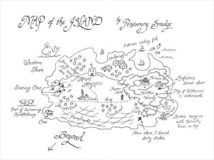
You can imagine my pleasure, then, when my editor asked me to draw a map for my middle-grade fantasy novel, The Rise and Fall of Mount Majestic, in the style the ten-year-old main character would do it. I was ready in a second, because throughout the writing process I had drawn and redrawn and redrawn maps of my little island, figuring out where the villages of Candlenut and Bristlebend were in relation to the oppressive pepper mill and the Willow Woods (where the restless mangroves and poison-tongued tortoises roam), how long it would take to climb to the Snoring Cave on the Western Shore, and how big Mount Majestic should be, with its slumbering giant buried underneath. I had to trace the path Persimmony Smudge would take on her hero’s journey.
What better way to nurture kids’ imaginations and sense of adventure (not to mention teach them about geography and cartography) than to encourage them to draw maps of their own fantasy lands?
So have a family map-making day.
Bring out those world atlases and globes and street maps as models (National Geographic has a great interactive map site.)
Perhaps start with a map of your own yard or town, but pepper it with magic trees, secret tunnels, fairy castles, and tongue-twisting words for ordinary places.
Make a list of all the things one might find on a map, and see how many you can fit in:
Mountains and hills
Rivers, waterfalls, swamps, lakes, and oceans
Caves
Cities and villages
Forests
Farmland
Roads
Haunted houses
Tree houses
Countries with strange names
Secret entrances to underground cities
Bridges with trolls under them
Castles
Forts
Robot factories
Harbors with ships
Buried giants
Monsters’ lairs
Deserts
Canyons
Hobbit holes
Launch pads for spaceships
Chart your course through seas and woods and mountain ranges.
Mark an X where buried treasure lies.
Leave plenty of mystery around the edges, with the words “Here be dragons.”
Make a map of a new world and go where no family has gone before.
BIO: Jennifer Trafton is the author of The Rise and Fall of Mount Majestic (Dial Book for Young Readers, 2010) for kids ages 9 – 12. She is a writer, editor, art lover, daughter of teachers, sister of musicians & actors, adoring dog owner, and incurable chocolate addict.
Want to know more? Read a summary of the book on Trafton’s blog. Sneak peak: Persimmony Smudge on the Island at the Center of Everything, weaving baskets and sweeping floors. Until, that is, the night she overhears a life-changing secret . . .
RELATED POSTS:

Looks like fun! When I was a child, I loved to draw my dream house, which always had entire rooms dedicated to things like “ice cream.” I think I also had a “volcano room,” for some strange reason…
My wife and I have a longstanding debate over maps in books. She *adores* them. I, on the other hand, have always felt that maps create an unwanted pressure for the reader. As though the author is saying “study up — this will be on the quiz!” Of course, I know in my head that authors are doing the opposite of this, but it still feels daunting.
I’m like you, I don’t bother with maps. But, one of my daughters seems to rely on the maps to orient herself in the book. Maybe she and your wife are more visual-spacial?
I can totally relate to loving books with maps. I can’t wait to read this one!
Great idea for my students!
What a great idea. My kindergartener created a map a few weeks ago and he was so proud of it! Thanks for sharing!